
Taiwan Turns to AI-Powered Satellite Intelligence to Track the PLA. Can It Reduce China's Operational Surprise?
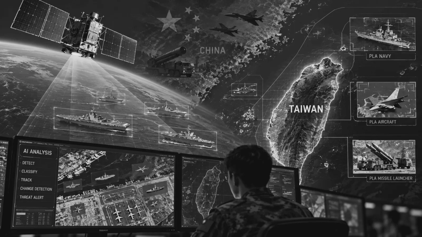
Taiwan's Ministry of National Defense has awarded a contract worth NT$46.55 million (approximately US$1.45 million) to develop an artificial intelligence-powered satellite imagery recognition system capable of detecting Chinese military assets and identifying changes in their deployment patterns. The system, scheduled for completion by April 2027, is reportedly designed to analyse satellite imagery covering 100 square kilometres within minutes, reducing the time and manpower required for conventional imagery interpretation. Its acquisition comes amid sustained Chinese military activities around Taiwan, including increasingly complex joint combat readiness patrols, maritime deployments and exercises that could complicate Taipei's ability to distinguish routine military pressure from preparations for offensive operations. CNAWS assesses with moderate confidence that AI-assisted imagery analysis could improve Taiwan's ability to identify unusual PLA movements, monitor mobilisation indicators and shorten the intelligence assessment cycle. However, the technology does not eliminate the constraints imposed by satellite revisit rates, weather, imagery resolution, camouflage and deception. Its strategic value will depend on integration with signals intelligence, radar, airborne surveillance and human intelligence rather than automated imagery recognition alone. The development also has implications for India, where Chinese military infrastructure expansion along the Line of Actual Control highlights the growing importance of persistent, multi-source surveillance and automated change detection.
Taiwan's New AI Satellite Intelligence System
On 17 October 2026, the South China Morning Post reported that Taiwan is acquiring an artificial intelligence-powered satellite imagery analysis system intended to improve the military's ability to monitor People's Liberation Army (PLA) deployments around the island. The system will reportedly identify military equipment, including ships, aircraft, missile launchers and other vehicles, while automatically comparing newly acquired satellite imagery with historical records to detect changes in deployment patterns.¹
The contract was awarded by the Communication Development Office (CDO) of Taiwan's Ministry of National Defense to ThinkTron Limited, a Taiwan-based geospatial technology company with Japanese industrial connections. The contract took effect on 25 September 2026, while the procurement award was publicly listed on 13 October. The recorded award value is NT$46,555,741, with completion expected by the end of April 2027.²
According to the reported specifications, the system can process a satellite imagery segment covering approximately 10 × 10 kilometres, equivalent to 100 square kilometres, within minutes. It is also intended to process multiple imagery segments and identify designated military objects through automated recognition.³
The acquisition is significant because it addresses one of the principal constraints in modern imagery intelligence, namely the time required to examine large volumes of satellite data and identify militarily relevant changes. Conventional satellite imagery interpretation depends heavily on trained analysts examining individual images, identifying objects, comparing imagery acquired at different times and determining whether observed changes have operational significance. While this process provides detailed intelligence, it becomes increasingly demanding when analysts must monitor multiple military bases, ports, airfields, missile installations and transportation networks simultaneously.
Artificial intelligence can reduce this burden by performing the initial identification and classification of objects, highlighting anomalies and presenting relevant imagery to analysts for further examination. For example, a system trained to recognise military aircraft could examine successive satellite images of an airbase and identify increases or reductions in aircraft parked in the open. Similarly, an automated change-detection system could identify newly constructed facilities, changes in military vehicle concentrations or the movement of equipment into previously unoccupied areas. The system could therefore help Taiwan move from predominantly manual imagery examination towards a more automated intelligence-processing architecture in which analysts spend less time searching through imagery and more time interpreting the significance of detected changes.
However, the procurement should not be mistaken for the acquisition of a new satellite or a continuously operating surveillance constellation. The publicly reported contract concerns imagery recognition and analysis software. Its performance will depend on the imagery supplied to it, including the availability, resolution and acquisition frequency of satellite data. Furthermore, the publicly available information does not establish the system's detection accuracy, false-positive rate, minimum reliable object-recognition threshold or the complete range of sensors whose data it will process. These factors will ultimately determine whether its advertised processing speed translates into operationally useful intelligence.
Growing PLA Military Pressure Is Compressing Taiwan's Warning Time
Taiwan's decision to invest in automated imagery interpretation must be understood within the changing operational environment across the Taiwan Strait. Over recent years, the PLA has substantially increased the frequency, geographical scope and complexity of its military activities around Taiwan. These activities include combat aircraft operating across the Taiwan Strait median line, naval deployments around the island, joint combat readiness patrols and large-scale exercises designed to demonstrate the PLA's ability to conduct coordinated operations.
According to Taiwan's Ministry of National Defense, between 1 January and 30 September 2025, approximately 3,003 sorties by PLA aircraft crossed the Taiwan Strait median line or entered Taiwan's southwestern and eastern airspace. During the same period, the ministry recorded approximately 2,000 sorties by PLA naval vessels within Taiwan's air-defence identification and contingency zones. The ministry further assessed that the PLA was conducting joint combat readiness patrols approximately three to four times per month.⁴ These figures illustrate the sustained intensity of Chinese military activity around Taiwan and the resulting demand placed on its intelligence and surveillance infrastructure.
The PLA's growing operational tempo creates a particular challenge because exercises, readiness patrols and actual military preparations can share several observable characteristics. Aircraft deployments, naval movements, activation of radar systems and concentration of military assets can occur during routine training as well as during preparations for offensive operations. The problem for Taiwan is therefore not simply detecting the presence of Chinese military forces. It is identifying when the scale, composition, location or timing of those forces begins to depart from established patterns.
This challenge has become more pronounced as the PLA develops the ability to conduct geographically dispersed and increasingly integrated operations involving air, naval, missile and supporting forces.
A February 2026 assessment by the ChinaPower Project at the Center for Strategic and International Studies (CSIS) found that Chinese military activities across the Indo-Pacific increased during 2025, including a record level of air and maritime activity around Taiwan. The study also identified two major exercises conducted during the year, Strait Thunder-2025A and Justice Mission 2025.⁵ More recently, on 12 October 2026, Taiwanese Defence Minister Wellington Koo confirmed that Taiwan was closely monitoring a series of Chinese live-fire exercises along the mainland coast. Although these exercises were not taking place directly around Taiwan, the nearest announced activity was off Zhejiang province, demonstrating the geographical breadth of military activities requiring Taiwanese surveillance.⁶
The operational concern is that the PLA could exploit the familiarity created by repeated exercises to complicate Taiwanese assessments of its intentions. If military deployments and joint exercises become sufficiently routine, unusually large or geographically dispersed force concentrations may not immediately produce the level of concern they would have generated under less active conditions. Taiwan's defence establishment has explicitly warned about the risk of the PLA transitioning from routine training to exercises and from exercises to actual war.⁴ Consequently, an increasingly important task for Taiwanese intelligence is to identify subtle but significant changes within an already elevated baseline of Chinese military activity. This is where automated satellite imagery interpretation could provide operational value.
How AI-Enabled GEOINT Could Strengthen Taiwan's Early-Warning Architecture
Geospatial intelligence, or GEOINT, involves analysing imagery and geospatial information to understand activities, infrastructure and developments at specific geographical locations. When combined with artificial intelligence, GEOINT can support automated object detection, classification, change detection and the identification of unusual spatial patterns.
The principal advantage of AI-enabled GEOINT is its ability to process large quantities of imagery systematically and identify developments that merit closer examination by intelligence analysts. In Taiwan's case, the technology could improve surveillance of Chinese naval facilities, airbases, missile-related infrastructure, military logistics hubs and transportation networks supporting potential operations across the Taiwan Strait.
Its first major application would be automated military-object recognition. Machine-learning models trained on suitable imagery could identify visible aircraft, naval vessels, military vehicles and other equipment, allowing analysts to monitor changes in their presence and distribution across selected locations.
The second application would be temporal change detection. By comparing newly acquired satellite imagery with earlier observations, the system could identify construction activity, changes in infrastructure, unusual equipment concentrations or shifts in the utilisation of military facilities. Such changes become particularly important when examined over an extended period. The construction of a new military facility, for example, may indicate a gradual expansion of operational capacity rather than an imminent military operation. A sudden increase in equipment concentration at an existing facility may have different implications, particularly if corroborated by other intelligence.
The third application would be the identification of deviations from established activity patterns. An intelligence system with access to sufficient historical imagery could help establish a baseline for activity at selected military facilities. Subsequent observations could then be examined against this baseline to identify unusual changes. However, identifying an anomaly is not equivalent to identifying hostile intent. An unexpected deployment may represent an exercise, an inspection, equipment rotation, readiness activity or preparations for an operation. Determining its meaning requires contextual intelligence and human assessment.
The fourth application would involve intelligence prioritisation. Instead of manually examining every newly received satellite image with equal attention, analysts could concentrate on imagery segments where the system has identified potentially significant changes. This could be particularly useful during periods of heightened military tension, when the volume of imagery requiring examination may exceed the capacity of available intelligence personnel. Taiwan has already identified the integration of emerging technologies into military intelligence as a national defence priority. Its Ministry of National Defense has stated that it intends to develop AI-assisted battlefield-management capabilities to accelerate intelligence processing, improve early warning and support military decision-making.⁷
The newly contracted imagery-recognition system should therefore be viewed as one component of a broader effort to improve intelligence exploitation and decision-support capabilities.
Integration with SIGINT and Multi-Source Intelligence
Although automated satellite imagery analysis could improve the identification of visible military activity, imagery intelligence alone cannot provide a complete understanding of an adversary's operational intentions. Its value increases when combined with signals intelligence (SIGINT), electronic intelligence (ELINT), radar surveillance, airborne reconnaissance and other intelligence sources. Taiwan's Communication Development Office is associated with the collection and exploitation of communications-related intelligence. The selection of this organisation to manage the imagery-recognition procurement is therefore particularly relevant.
Reports describing the project indicate that imagery-derived observations could be correlated with communications and electronic intelligence to improve assessments of Chinese military activity.³ Such integration would allow different intelligence disciplines to support and validate one another. Satellite imagery may identify the presence of equipment at a military installation, while communications or electronic intelligence could provide additional information concerning activity associated with that location.
Similarly, radar and airborne surveillance could help determine whether activity detected in satellite imagery forms part of a broader pattern of military movements. The analytical objective would be to move beyond isolated observations towards a consolidated assessment of the adversary's operational posture. This approach is consistent with Taiwan's existing intelligence-modernisation programme. Its Ministry of National Defense has described the use of a Common Intelligence Imagery System to integrate information from multiple sources and support real-time situational awareness.⁴
Nevertheless, the publicly available procurement information does not establish precisely how the new AI system will connect with existing SIGINT databases, military command systems or intelligence-sharing arrangements. The difference between potential integration and demonstrated integration is important. A system capable of rapidly detecting objects in satellite imagery will provide limited strategic benefit if its findings remain confined to a separate analytical platform or reach operational decision-makers only after substantial delays. Effective early warning depends not only on detecting information but also on validating, interpreting and communicating it. Accordingly, the operational success of Taiwan's initiative will depend on whether imagery-derived alerts can be combined with other intelligence sources and incorporated into established assessment and decision-making processes.
Can AI Reduce the Risk of Chinese Operational Surprise?
The most important question is whether Taiwan's investment can materially reduce the possibility of being surprised by a major Chinese military operation. The answer depends on distinguishing between the speed of intelligence processing and the ability to obtain timely intelligence in the first place. Taiwan's proposed system could significantly reduce the time required to analyse satellite imagery once that imagery becomes available. However, faster processing does not necessarily mean that relevant locations are being observed continuously.
A satellite may acquire imagery of a military facility only at particular intervals, depending on its orbital characteristics, imaging capabilities, access arrangements and tasking priorities. If significant military activity occurs between successive observations, an automated recognition system may not identify the development until the next usable image is acquired. This distinction is particularly important when considering the reported ability to analyse 100 square kilometres within minutes. The figure describes the processing capability for an imagery segment. It does not establish that Taiwan can collect fresh imagery of every location within that area continuously, nor does it demonstrate that the entire Chinese coastline can be monitored in real time.
A useful distinction can also be made between strategic warning and operational warning. Strategic warning concerns the identification of broader changes that may indicate preparation for military confrontation, including unusual mobilisation, expanded logistical activity and changes in force posture. Operational warning concerns more immediate developments that indicate military forces may be preparing to undertake specific actions. AI-assisted imagery analysis could support both functions, but the requirements differ. Long-term change detection may be sufficient for identifying the expansion of military infrastructure, while time-sensitive operational warning requires more frequent observations and faster intelligence dissemination.
The technology is therefore likely to provide the greatest immediate benefit in monitoring selected facilities and identifying changes in established activity patterns. Its ability to provide warning of rapidly developing operations will remain dependent on the wider surveillance architecture. CNAWS assesses with moderate confidence that Taiwan's acquisition could improve the consistency and speed of its imagery exploitation. However, its ability to reduce actual operational surprise remains conditional on the availability of timely imagery, reliable detection performance and effective integration with other intelligence disciplines.
Technical Limitations and Vulnerabilities
Despite the operational advantages of AI-enabled satellite intelligence, the technology faces several limitations that could reduce its effectiveness against an adversary possessing substantial military and technological capabilities.
The first limitation concerns satellite revisit frequency and imagery availability. The ability to analyse imagery within minutes does not overcome gaps between successive satellite observations. Imagery acquisition, transmission, processing and delivery each contribute to the total time required before an intelligence assessment can be produced. Commercial imagery providers offer different combinations of resolution, revisit frequency and tasking flexibility. As a result, the effectiveness of automated analysis depends partly on the characteristics and availability of the imagery sources feeding the system.⁸
The second limitation concerns weather and atmospheric conditions. Electro-optical satellite imagery can be degraded or obstructed by clouds, haze and poor illumination. Such conditions are particularly relevant to the Taiwan Strait and adjacent coastal regions, where weather patterns can restrict optical observation. Synthetic Aperture Radar (SAR) offers an important complementary capability because it can acquire imagery during both day and night and through cloud cover. However, radar imagery differs from conventional optical imagery and requires specialised interpretation and suitable analytical models.⁹
The third limitation concerns resolution and object recognition. The ability to recognise a military object depends on the size of the object, the resolution of the image, the viewing geometry and the characteristics of the recognition model. Even when a system detects an object correctly, determining its specific type or operational role may remain uncertain. For example, an automated system may identify a vehicle-shaped object without reliably establishing whether it is a military transporter, civilian truck or specialised military platform.
The fourth limitation concerns errors in automated recognition. Machine-learning models can generate false positives, where ordinary objects are incorrectly identified as military targets, and false negatives, where actual military equipment goes undetected. Such errors can become particularly consequential when intelligence assessments are produced during a period of heightened military tension. A false identification could produce an unnecessary warning, while the failure to identify a genuine change in force deployment could create misplaced confidence in the prevailing assessment.
The fifth limitation concerns concealment, camouflage and deception. Military organisations can employ camouflage, decoys, covered facilities, dispersal and other deception measures to complicate external observation. AI-based image recognition does not eliminate these challenges. A system trained primarily on conventional examples of military equipment may perform less reliably when examining unfamiliar camouflage arrangements, partially concealed objects or environments that differ substantially from its training data.
The sixth limitation concerns data integrity and system security. AI-assisted intelligence systems depend on the reliability of incoming data, secure communications and the integrity of their processing environments. Disruption, manipulation or corruption of these components could degrade the accuracy and availability of intelligence outputs. Consequently, the introduction of artificial intelligence also creates additional requirements for validation, cyber protection, model maintenance and human oversight.
These limitations reinforce an important conclusion. AI can accelerate the identification of observable military developments, but it cannot independently establish an adversary's intentions or eliminate uncertainty from intelligence assessments.
Implications for India and Surveillance Along the LAC
Taiwan's acquisition has important implications for India because both countries face the challenge of monitoring Chinese military activities across geographically extensive and operationally demanding environments. However, the nature of the challenge differs considerably.
Taiwan's principal concern is the movement and concentration of Chinese air, naval and supporting forces in preparation for possible operations across the Taiwan Strait. India's primary surveillance requirements along the Line of Actual Control (LAC) concern military infrastructure, force deployments, logistics, transportation networks and changes in the operational posture of PLA formations across mountainous terrain.
The importance of persistent surveillance along the LAC has increased as China continues to develop military and dual-use infrastructure across Tibet and Xinjiang. Satellite imagery assessments conducted by CSIS have documented the expansion of Chinese military and dual-use facilities along the disputed border, including roads, military installations and border settlements. A 2024 ChinaPower assessment examined the expansion of Chinese dual-use villages near Arunachal Pradesh, identifying new structures, possible military facilities and associated infrastructure through the comparison of satellite imagery acquired over several years.¹⁰ Separate CSIS research has documented the expansion and modernisation of Chinese airfields, heliports and supporting military infrastructure across Tibet and Xinjiang, including facilities that could improve the PLA's ability to deploy and sustain forces near the Indian border.¹¹
These developments illustrate the value of systematic monitoring over extended periods. An individual satellite image may reveal the presence of a road, building or military facility. However, comparing imagery over time can provide a clearer understanding of when construction began, how rapidly it progressed and whether the facility's apparent operational role has changed. For India, AI-assisted change detection could help analysts examine large quantities of imagery from selected areas along the LAC and identify developments that warrant further investigation.
The potential applications extend beyond identifying visible military equipment. They include monitoring infrastructure development, changes in transport connectivity, alterations to permanent military facilities and broader changes in activity patterns. Nevertheless, India's geographical and environmental conditions introduce additional technical difficulties. High-altitude terrain, persistent cloud cover in some sectors, seasonal snowfall and the complex geometry of mountainous landscapes can reduce the effectiveness of conventional optical imagery.
Radar imagery can provide an important complementary source, although mountainous terrain introduces challenges associated with radar shadows, geometric distortion and the interpretation of complex surface features. A reliable analytical system for the LAC would therefore require suitable combinations of optical imagery, radar imagery and other intelligence sources, supported by models trained and validated for Himalayan terrain.
Importantly, India is not starting from an absence of technological capability. In January 2025, the Ministry of Defence introduced SANJAY, an automated Battlefield Surveillance System designed to integrate inputs from ground-based and aerial sensors, verify information, prevent duplication and produce a common surveillance picture through secure military networks. The system is intended to improve situational awareness and support intelligence, surveillance and reconnaissance across India's land borders.¹²
India has also continued expanding its space-based observation capabilities. The NASA-ISRO Synthetic Aperture Radar (NISAR) mission, launched in July 2025, provides L-band and S-band radar observations. ISRO announced the release of NISAR S-band data products in July 2026, including observations over the Indian landmass.¹³ NISAR is primarily a scientific Earth-observation mission and should not be characterised as a dedicated tactical military reconnaissance satellite. Its relevance to this discussion lies in the growing availability of radar-imaging data and the technical capabilities associated with space-based observation.
The broader lesson from Taiwan's procurement is therefore not that India should replicate the same system, but that intelligence modernisation increasingly requires closer integration between surveillance platforms, automated analytical tools and operational decision-making structures. India's ability to obtain imagery is only one part of this process. Equally important is the capacity to process incoming information, identify relevant developments and compare observations across different intelligence sources.
For the LAC, such an approach could help improve the continuity of surveillance and reduce the analytical burden associated with examining large geographical areas. However, it would remain essential to distinguish observable activity from inferred intentions and to ensure that automated alerts are subjected to human verification before informing consequential military decisions.
Outlook and Indicators to Monitor
The first indicator will be the completion and acceptance of Taiwan's AI satellite imagery recognition system, currently scheduled for April 2027. Successful delivery would demonstrate that the programme has progressed beyond procurement, although its operational capabilities would still require evaluation.
The second indicator will be the disclosure of technical performance parameters. Information concerning object-detection accuracy, false-positive rates, supported imagery types and processing capacity would provide a clearer basis for assessing the system's operational utility.
The third indicator concerns imagery access and collection arrangements. Agreements with commercial satellite operators, improvements in Taiwan's indigenous Earth-observation capabilities and the availability of additional radar imagery would directly influence the quantity and timeliness of data available for analysis.
The fourth indicator will be integration with existing intelligence systems. Evidence that automated imagery-derived findings are being incorporated into Taiwan's broader intelligence and command architecture would indicate that the acquisition is contributing to more than standalone image processing.
The fifth indicator concerns the role of human analysts. The development of procedures for verifying automated detections, assigning confidence levels and distinguishing anomalies from operationally significant changes will be important for assessing the reliability of the system.
The sixth indicator will be the PLA's response to increasingly automated Taiwanese surveillance. Any observable changes in the use of camouflage, dispersal or deception would merit assessment, although such developments could arise from wider PLA operational requirements rather than Taiwan's specific acquisition.
Finally, further investment by Taiwan in AI-enabled intelligence, surveillance and reconnaissance systems would indicate whether automated imagery recognition is being institutionalised as a regular component of its defence architecture.
Strategic Assessment
CNAWS assesses with moderate confidence that Taiwan's acquisition of an AI-powered satellite imagery recognition system represents an incremental but potentially significant improvement in its military intelligence-processing capabilities. The system's principal advantage is not the creation of an entirely new surveillance capability but the ability to extract operationally relevant information more rapidly from imagery that Taiwan can already obtain or may acquire in the future.
This distinction is critical. Modern intelligence organisations increasingly face a situation in which the volume of information collected exceeds the capacity of available analysts to examine it comprehensively. Artificial intelligence offers a means of reducing this imbalance by automating initial recognition, classification and change detection.
In Taiwan's case, the value of this capability is heightened by the PLA's increasingly frequent and complex military activities around the island. As Chinese military deployments become more routine, Taiwan must identify changes that indicate a meaningful departure from established behaviour. Automated imagery analysis could improve the consistency and speed of such assessments, particularly when correlated with signals intelligence, radar surveillance and other sources.
Nevertheless, the procurement does not eliminate the possibility of Chinese operational surprise. Even highly capable imagery-recognition systems remain dependent on the frequency of satellite observations, the quality of incoming data and the ability of intelligence organisations to interpret detected developments correctly. The absence of visible military activity cannot automatically be treated as evidence that no preparations are underway.
The larger strategic significance lies in the gradual integration of artificial intelligence into military intelligence architectures. For India, Taiwan's initiative reinforces the importance of developing intelligence systems capable of transforming satellite and other sensor data into timely, verified and operationally relevant assessments. India's surveillance challenges along the LAC differ from Taiwan's maritime and air-defence requirements, but both environments demonstrate that the effectiveness of modern intelligence increasingly depends on the relationship between collection capacity, automated processing and human analytical judgement.
The adoption of AI will not remove uncertainty from military intelligence. Its principal contribution will be to help intelligence organisations examine larger datasets more systematically and devote greater analytical attention to developments that may otherwise be overlooked.
Conclusion
Taiwan's investment in AI-powered satellite imagery recognition reflects a wider transformation in the conduct of military intelligence, where the ability to process and interpret information is becoming as important as the ability to collect it.
The proposed system could strengthen Taiwan's monitoring of PLA activities by accelerating object recognition, improving change detection and reducing the workload associated with manual imagery interpretation.
However, the system's ability to reduce Chinese operational surprise will depend on factors extending beyond the performance of its artificial intelligence models. Satellite revisit frequency, data availability, integration with other intelligence sources and the reliability of analytical assessments will continue to determine the effectiveness of Taiwan's early-warning architecture.
For India, the development offers a relevant example of how emerging analytical technologies can complement existing surveillance capabilities in an environment characterised by extensive military infrastructure and persistent strategic competition.
The decisive advantage in modern intelligence may increasingly belong not to the side that collects the greatest volume of information, but to the side that can identify, verify and interpret operationally significant changes before they translate into a strategic surprise.
References
Lawrence Chung, “How Taiwan’s New AI Satellite System Aims to Speed Up Early Warning Against PLA Moves,” South China Morning Post, October 17, 2026.
Taiwan Ministry of National Defense, “Satellite Image AI Automatic Recognition System, Tender No. HP15077L182,” procurement award notice reproduced by BeranIQ, October 13, 2026.
Thomas Kerval, “Taiwan Orders AI Satellite Imagery System to Spot PLA Ships and Launchers in Minutes,” Defense Warroom, October 17, 2026.
Ministry of National Defense, Republic of China, “Evolving Threats from PLA’s Activities,” October 1, 2025.
Bonny Lin, Brian Hart, Leon Li, and Truly Tinsley, “Tracking China’s Increased Military Activities in the Indo-Pacific in 2025,” ChinaPower Project, Center for Strategic and International Studies, February 5, 2026.
Reuters, “Taiwan Says It Is Closely Monitoring a Series of Chinese Live-Fire Drills,” October 12, 2026.
Ministry of National Defense, Republic of China, “Application of Emerging Technologies,” October 1, 2025.
U.S. Government Accountability Office, “National Security Space: Overview of Contracts for Commercial Satellite Imagery,” GAO-23-106042, 2022.
National Aeronautics and Space Administration, “CSDA Program Announces Eight New Data Agreements,” 2026.
ChinaPower Project, “China Is Upgrading Dual-Use Villages along Its Disputed Indian Border,” Center for Strategic and International Studies, 2024.
ChinaPower Project, “How Is China Expanding Its Infrastructure to Project Power Along Its Western Borders?,” Center for Strategic and International Studies, 2022.
Ministry of Defence, Government of India, “Raksha Mantri Shri Rajnath Singh Flags-Off ‘SANJAY – The Battlefield Surveillance System’ from New Delhi,” Press Information Bureau, January 24, 2025.
Indian Space Research Organisation, “NISAR S-Band SAR Data Products Release,” July 24, 2026.
Tags
Author